Freshwater-specific environmental variables
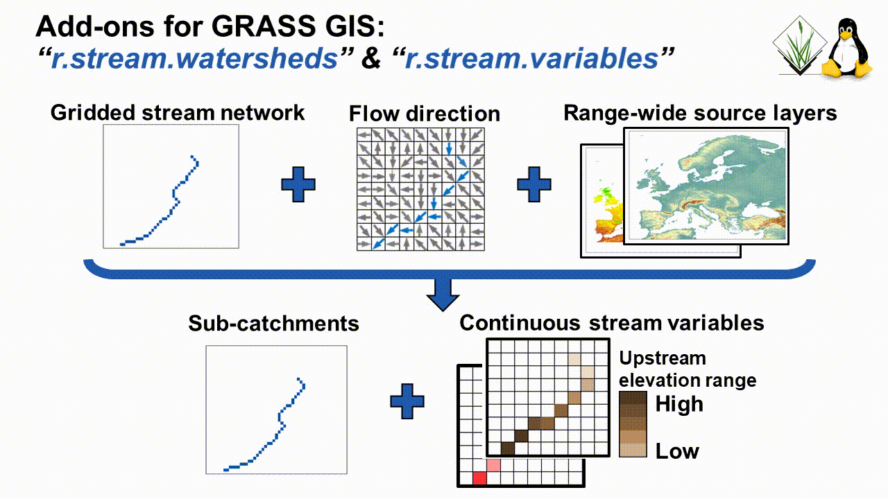
This tutorial shows you how to calculate stream-specific freshwater variables by relating the upstream e.g. land cover to any given downstream location using the GRASS GIS add-ons r.stream.watersheds & r.stream.variables. The original 1km data and publication are available here - see also the original code from spatial-ecology.net.
This example contains the following steps:
- Download an exemplary digital elevation model (DEM)
- Extract the stream network from the DEM
- Delineate major drainage basins
- Crop data to a sub-basin
- Calculate the sub-watersheds for each stream grid cell (r.stream.watersheds)
- Calculate contiguous stream-specific variables (r.stream.variables)
Create and enter the folder where the data will be stored:
export INDIR=$HOME/grass_hydro
mkdir $INDIR
cd $INDIR
Download the script
cd ~
wget "http://www.spatial-ecology.net/ost4sem/exercise/basic_adv_grass/stream_variables.sh"
rstudio stream_variables.sh &
Download and unzip a DEM from WorldClim:
wget -O  $INDIR/alt_16_tif.zip  "http://biogeo.ucdavis.edu/data/climate/worldclim/1_4/tiles/cur/alt_16_tif.zip"
unzip  -o $INDIR/alt_16_tif.zip  -d  $INDIR/dem
gdalinfo $INDIR/dem/alt_16.tif        # check data
If needed, first install the latest GRASS GIS version:
sudo add-apt-repository ppa:ubuntugis/ubuntugis-unstable
sudo add-apt-repository ppa:grass/grass-devel
sudo apt-get update
sudo apt-get install grass grass-gui grass-dev subversion gdal-bin libgdal-grass libalgorithms1 libbase1 libgdal-dev
Create the GRASS GIS data base and enter GRASS:
grass78 -text -c $INDIR/dem/alt_16.tif $INDIR/grass_location
Read data into GRASS:
r.in.gdal input=$INDIR/dem/alt_16.tif    output=elevation
r.info elevation # check data
Open GUI and visualize the layers:
g.gui wxpython
Run hydrological conditioning:
g.extension  extension=r.hydrodem # download extension
# if you get an error run: sudo apt install grass-dev subversion
r.hydrodem  input=elevation  output=elevation_cond
Extract drainage direction and stream network
r.watershed  --h  # see help regarding the options and flags
r.watershed  elevation=elevation_cond  drainage=drainage   stream=stream  accumulation=accumulation  threshold=100  --o
Get drainage basins (last downstream segment: -l flag)
g.extension  extension=r.stream.basins
r.stream.basins  direction=drainage  stream_rast=stream  basins=basins_last  -l  --o
Categorize the single basins:
r.clump -d input=basins_last output=basins_cat --o
Extract the data for one basin:
r.mapcalc "drainage_sub = if (basins_cat==798, drainage, null() ) "  --o
r.mapcalc "stream_sub = if (basins_cat==798, stream, null() ) "  --o
Write files to disk:
r.out.gdal  input=drainage_sub   output=$INDIR/drainage_sub.tif  type=Int32  nodata=-9999  --o  -c    createopt="COMPRESS=LZW,ZLEVEL=9"
r.out.gdal  input=stream_sub     output=$INDIR/stream_sub.tif    type=Int32  nodata=-9999  --o  -c    createopt="COMPRESS=LZW,ZLEVEL=9"
Create stream-specific variables, and limit the calculation only to a single basin.
Download and install the GRASS add-ons. Work-around (December 2019) for grass78:
mkdir $HOME/.grass7/addons/scripts
wget -O $HOME/.grass7/addons/scripts/r.stream.watersheds "https://raw.githubusercontent.com/domisch/grass-addons/master/r.stream.watersheds"
chmod 777  $HOME/.grass7/addons/scripts/r.stream.watersheds

wget -O $HOME/.grass7/addons/scripts/r.stream.variables "https://raw.githubusercontent.com/domisch/grass-addons/master/r.stream.variables"
chmod 777  $HOME/.grass7/addons/scripts/r.stream.variables
Add-on 1: Calculate the sub-watershed and sub-stream sections for each stream grid cell using 2 processors:
r.stream.watersheds stream=stream_sub drainage=drainage_sub cpu=2
Add-on 2: Create stream-specific variables based on elevation
r.stream.variables variable=elevation output=cells,min,max,range,mean,stddev,coeff_var,sum area=watershed scale=1 cpu=2
Rename the “elevation_cells” to “flow_accumulation” and check variables:
r.mapcalc "flow_accummulation = elevation_cells"  --o
r.info  flow_accummulation
r.info  elevation_range
Get stream length (similar procedure as above):
r.stream.variables  variable=elevation  output=cells  area=stream  scale=1  cpu=2
r.mapcalc "stream_length = elevation_cells"  --o
r.info  stream_length
Calculate the amount of rainfall within the basin:
wget -O  $INDIR/prec_16_tif.zip  "http://biogeo.ucdavis.edu/data/climate/worldclim/1_4/tiles/cur/prec_16_tif.zip"
unzip -q  -o $INDIR/prec_16_tif.zip  -d  $INDIR/prec
r.in.gdal input=$INDIR/prec/prec6_16.tif   output=prec6   # rainfall in June
r.stream.variables  variable=prec6  output=sum  area=watershed  scale=1  cpu=2
Run all 12 months in a loop:
for var in $(seq 1 12); do
r.in.gdal input=$INDIR/prec/prec${var}_16.tif   output=prec$var
r.stream.variables  variable=prec$var  output=sum  area=watershed  scale=1  cpu=2
done
Other useful add-ons for hydrological applications: http://grasswiki.osgeo.org/wiki/Hydrological_Sciences
Other examples
Get the stream order:
r.stream.order stream_rast=stream direction=drainage strahler=str_order --o
Get only streams and basins >=3rd order
r.mapcalc "str_order_3rd = if(str_order >=3, str_order, null() ) "  --o
r.stream.basins  direction=drainage  stream_rast=str_order_3rd  basins=basins_3rd_last   -l  --o
Stream distance - Calculates distance to and elevation above streams and outlet
g.extension extension=r.stream.distance
r.stream.distance   stream_rast=stream   direction=drainage   elevation=elevation_cond  method=downstream   distance=str_distance    difference=str_elevation_diff  --o
Stream order statistics - Calculates Horton’s statistics for Strahler and Horton ordered networks created with r.stream.order Print only order statistics:
g.extension extension=r.stream.stats
r.stream.stats  stream_rast=stream   direction=drainage   elevation=elevation_cond  output=str_stats_o.txt    --o
more $INDIR/str_stats_o.txt
Print only catchment statistics:
r.stream.stats  stream_rast=stream   direction=drainage   elevation=elevation_cond  output=str_stats_c.txt    -c
more $INDIR/str_stats_c.txt
See also these useful GRASS-GIS commands for hydrological applications:
https://grass.osgeo.org/grass78/manuals/topic_hydrology.html
https://grasswiki.osgeo.org/wiki/R.stream.*_modules
https://grasswiki.osgeo.org/wiki/Hydrological_Sciences